Sunday, October 30, 2016

Torres del Paine National Park, Chile

Sorry for the delay folks! The end of the trip was a blur with no time to write. But I will be posting from home about our last few stops - Torres del Paine National Park Chile, La Paz Bolivia and Lake Titicaca Peru.

After leaving Buenos Aires, we flew down over the Pampas (the Great Plains of Argentina) and across the eastern side of Patagonia. We landed in Punta Arenas but did not go into the city proper. Instead, we drove 3 hours east and north through the Patagonian landscape to Puerto Natales.

We often board our private jet using stairways out on the tarmac. This gives us an opportunity to be greeted by our captain, Peter Wittik whom I have flown with before on an Around the World trip in 2013. Our jet is fabulous!

Here I am with my fellow lecturer, Hugh Neighbor. Hugh is a former employee of the US State Department with assignments in Fiji, Bolivia, and Austria. We give our lectures in the space just in front of our seats. It's a neat system - our lectures are broadcast over Wi-Fi onboard and the passengers see the slides on iPads and hear our voices over Bose headphones.

Lifting off out of Buenos Aires. The sun finally came out. We had two days of rain prior.

The Straits of Magellan in the southernmost part of South America.

On the way to Puerto Natales, we had lunch at a Patagonian estancia (ranch).

They raise llamas and sheep here and a gaucho was rounding up a herd of llamas. I include a few scenics of this.

Llamas on the Patagonian landscape.

Near the corral.

A young, curious llama.

The following day we were on our way to the national park out of Puerto Natales. You can see the lines in the snow that denote sedimentary rocks in the landscape. These are mostly Cretaceous shales, sandstones, and conglomerate.

We entered the park from the east side and got our first view of the Paine massif in the distance. There is often overcast, rainy weather here so I was so pleased to see that we would have a nice day.

As we neared the park the details of the rocks became obvious. These are the Cuernos de Paine (cuernos = horns; paine = blue and pronounced pie-nay). More on these later but note the black caps on top of light-colored granite.

These are the Torres del Paine (torres = towers). I hiked up to the base of the towers in 1993 on a seven-day backpack and would love to do that again.

A wide view of the Patagonian sky! The east side of the park is by far the sunniest as the massif creates a massive rain shadow.

Reflections on Lago Amarga (Bitter Lake).

The granite is a mere 12 million years old and has cooled, crystallized and been brought to the surface and eroded in that short amount of time. It likely was not emplaced too deeply - perhaps only 2 to 2.5 miles down.

To the south (the part of the park that no one except crazy geologists look towards since the Towers and Cuernos are to the north) are black shales of the Cerro Toro Formation. These rocks were laid down in the Cretaceous Magallanes basin ∼100 Ma, which was then located in the South Atlantic Ocean. The shales were laid down in about 6,000 feet of water, explaining their fine-grained nature.

However, within the shale are these very coarse conglomerates - an odd relationship. How could these well-rounded cobbles and bounders become interbedded with fine-grained, deep-water shale? The answer is seismicity! In the Cretaceous, the early Andes Mountains were being uplifted and shading coarse sediment to the east to the coastal margin of the Magallanes basin. When earthquakes related to the tectonic setting mobilized the nearshore gravel and cobbles, they became entrained in submarine debris flows called turbidites. Amazing preservation of a tectonically active margin.

A Nineo plant (Anarthrophyllum desideratum) frames a beautiful view of Lago Nordenskiold and the Cuernos del Paine. The bright red flowers are a sure sign of spring in Patagonia.

So what about these variably colored rocks in the Cuernos and Towers? The black caps are the shales of the Cerro Toro Formation and the light-colored granite intruded into it about 12 Ma, forming a laccolith (lacco = Gr. for cistern or chamber). A laccolith is a mushroom shaped intrusion. This laccolith is highly dissected giving the interesting distribution of rock type and color. Glaciers carved the deep valleys on the flanks of the massif.

This is the highest peak in the Paine massif, Cerro Paine Grande (Big Paine Peak) at 9,462 feet. It is capped with the black shale turbidite.

A final view of the Cuernos del Paine as we head back to Puerto Natales.

Thursday, October 20, 2016

Iguaçu Falls, Brazil and Argentina


Iguaçu Falls straddles the Brazil/Argentina border and was voted in 2014 as one of the New Seven Natural Wonders of the World. (Of course, this list was a bit of a sham as anyone could vote as often as desired for their favorite place - some picks were flooded by citizens in entire counties - see the whole list here, especially the criticisms section). You have to wonder about a list that doesn't include the Grand Canyon (see the original list here).

Still we had a great visit here and enjoy the photos.

A very hazy approach to the Iguaçu River, a large meandering stream that is tributary to the great Paraná River.

We landed on the Argentinian side of the border but were staying on the Brazilian side. As we crossed from one country to the other over the river, the colors reflected the change.

The Iguana River isa  placid stream below the falls, located about 14 miles upstream from this spot.

A giant cumulonimbus cloud towers over the Das Cataratas Hotel near the lip of the falls. This grand hotel was an excellent place to stay and is the only hotel inside the Brazilian National Park.

This photo was taken from the same spot as the previous one but looks toward the Argentinian side of the falls.

A better view.

A trail leads along the edge of the gorge about 3/4 of a mile. It was hot and steamy at 4 in the afternoon.

It has been estimated that the falls migrate upstream about 1 inch every 10 to 25 years and that this rate has ben going on for a least 32 million years, when the falls would have been located 14 miles farther downstream and at the junction with the Paraná River.

Different levels of the falls are produced when they cascade into interbedded paleosols (ancient soils formed on top of earlier lava flows). These lines of weakness help to form platforms in the falls.

The sound and the fury of the water was incredible. I used to think that Victoria Falls in Africa were the greatest falls but I may have changed my mind on this visit.

The calculated discharge at the time of these photographs was 85,000 cfs.

A graph from my onboard lecture shows a comparison with Earth's greatest waterfalls. Note the record discharge at Iguaçu was only a little more than two years ago.

Photograph of the June, 2014 flood from a local newspaper.

This the Devil's Throat where the head of the falls is located.

Note how the river is slicing down through the hard basalt bedrock.

Graphic from my lecture showing the relationship of the lava flows when the Gondwana supercontinent existed some 130 Ma.

The Devil's Throat.

The final platform at the Devil's Throat. Here, camera's and bodies get wet from the mist.

Visible is about half the height of the falls.

Out on the final platform. Look at the scale of the falls - they are huge!

Looking downstream from the final platform.

Iguaçu Falls.


An elevator exists to take people to the very top of the falls.

From the top looking upstream into the Devil's Throat.

Sunset at Iguaçu Falls and a towering cloud. Off to Buenos Aires!

Tuesday, October 18, 2016

Rio de Janeiro, Brazil

After leaving Cartagena, Colombia, we embarked on a seven-hour flight across the wide heart of the South American continent. I gave my first lecture concerning our two stops in Brazil at Rio de Janeiro and Iguaçu Falls. It was overcast for much of the flight but we did see a few features along the way. I missed the photo of the equator.

Crossing the great Amazon River about 200 miles west of Manaus, Brazil.

A large southern tributary of the Amazon. These rivers are huge!

Closer to Rio, we saw towering cloud formations. The photo does not do justice for the scale of these teeming columns of water vapor.

Avenues of clouds and thunderstorms. It was amazing.

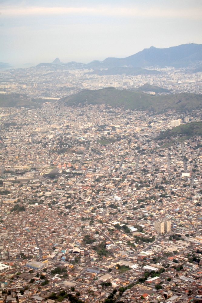
Looking across the northern suburbs of Rio de Janeiro toward the Tijuca Forest (mountain in the upper right) and the sentinel of the Paõ de Açucar or Sugarloaf Mountain in the distance on the left.

Coming in to the landing with downtown Rio and the Sugarloaf visible.

Rio is a city of tunnels, built to ease traffic through the granite mountains.

The train station at Corcovado in the Cosme Velho neighborhood. This cog railway train brings people top the top of Corcovado Mountain at 2,300 feet, where the Christ the Redeemer statue is located.

Sycamore tree trunk and street art across from the train station. Rio is rife with graffiti and street art. It is everywhere. Note the obscure graffiti to the left of the tree - most of the street art is o this type.

The Christ the Redeemer statue is one of the biggest draws in the city. In 2011 it was voted  as one the New Seven Manmade Wonders of the World.

The view from the statue platform looking toward the Lagoa de Freitas and Ipanema Beach.

View from the Sugarloaf Mountain to Corcovado Mountain. A fog enveloped the Sugarloaf in the afternoon but this view appeared for five seconds. Otherwise it was gray fog the whole time.

On this trip I visited places in downtown Rio that I had never stopped at before.

This is the Saõ Sebastiaõ Cathedral (or Metropolitan Cathedral) and I had never before stopped here. From the outside it looks like a Mayan temple and is said that 20,000 people can stand inside of it.

The light coming through he stained glass panels was an exceptional sight.

Beautiful!

The modern skyline of Rio de Janeiro is perhaps an unknown aspect of the city, compared to its more famous beach scenes.

This is the landing for the original port in Rio. You can see the stairways that led down to the water, now located about 100 meters behind the photograph.

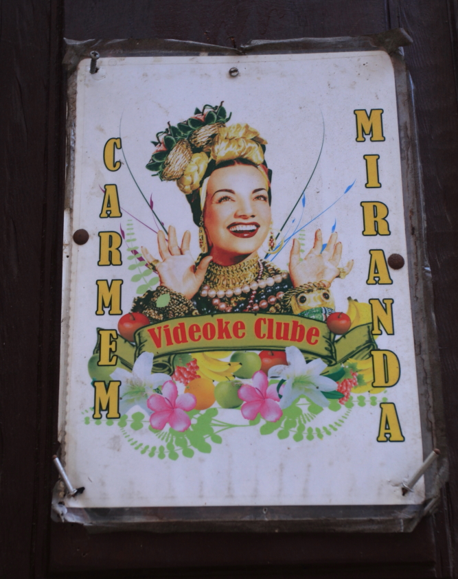
Carmen Miranda is a legend in Rio and I never knew anything about her until I read this.

There is a lot of work to be done to rehabilitate the original commercial district in Rio but the "bones" for future work are tere.

More street graffiti. This type of art tends to diminish the overall beauty of the city (and I only take pictures of the most striking forms - most of it is just black or white alphabetical gibberish) and the city fathers are trying to encourage street artists to up the quality of the art rather than stop it entirely.

However, the port section of town has been totally revitalized because of the 2014 World Cup and 2016 Olympic events.

This is the brand new Museo do Amanha (Museum of Tomorrow) and has a very interesting design.

#cidadeolimpica. See the short film here.

There is also a new light rail system in this part of the city. Rio has a fledgling subway system for its 6.5 million inhabitants.

We are now flying to Iguaçu Falls on the Argentinian border and saying goodbye to Rio. Here are a fews shots of the great views I had while leaving the city.

The entrance to Guanabara Bay with ships entering and leaving. The Paõ de Açucar guards the harbor entrance which was on the original list of the Seven Natural Wonders of the World. However, 70% of the city's sewage is now dumped into the bay untreated. What once was a tropical paradise has been been turned into a toxic soup. One hopes that in the future this can be rectified.

Much of the heart of Rio de Janeiro can be seen in this view. Note the tiny cloud on the far left drapping over the Paõ de Açucar and the small white dot of the Christ the Redeemer statue on the sharp peak just above the photo's center. Downtown Rio is where the tall buildings are seen on the far right center. The famous beaches of Copacabana and Ipanema face the South Atlantic Ocean at the far left.

Downtown with the new Museo do Amanha jutting out to the right within the bay.

Lastly, these are the two famous beaches in Rio - Copacabana Beach on the right and Ipanema on the left. We are now on our way to Iguaçu Falls!