My Grand Canyon 10-Day rafting trip this year was extra special. We had 13 excited participants ready to learn a little geology and take some hikes to Grand Canyons' great places. But also, there were two special family member's along, my wife Helen and her dad Joel. This posting features photographs 100% from Helen who is becoming a sensational photographer before our eyes. Enjoy the canyon through Helen's lens!
By the way, these are photo's taken with her iPhone. A nicer camera is on its way to her soon! Thanks to all of our great guests on the river: Mike and Rebecca (repeats from 2013), Darroy, Pat and Penny (alumni from my 3-day Geology class on the South Rim), Bill, Parr (sixth trip with GCA), John P., Vicki, Deb, and brothers Rick and John. And our two boatmen Ed and Chad. You guys rock!
Helen and Joel on the drive up to Lees Ferry
Pointing out the scenery and stratigraphy from Navajo Bridge near the Vermilion Cliffs
The placid Colorado River at Lees Ferry. The colorful Vermilion Cliffs in the background capped by Navajo Sandstone.
Captain Ed giving us an orientation while on the river
Vicki, Penny and Deb are ready to go. Penny is an alumni of my three-day geology class on the South Rim, Geology on the Edge. See this link for information about the already completed 2014 class. Sign ups for the 2015 class, to be conducted from July 31 to August 2, will be open starting November 25. Visit the same link at that time, or write to me personally to hold space.
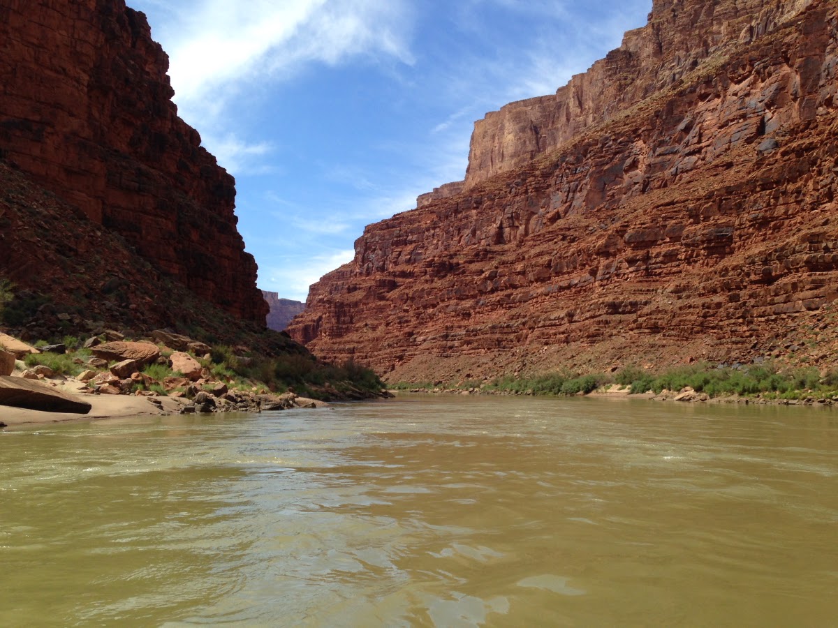
The Paria River experienced a flash flood event two days before the start of our trip and made the river a light brown color.
The Navajo Bridges from the river
No dieting allowed on river trips! Many have tried - all have failed. That's a good thing.
There's really nothing like going down the Colorado River in Grand Canyon with a geologist to point out all of the interesting and sometimes subtle features in the landscape. My role on these trips is 100% for the folks who pay to go, I have no kitchen or boat duties to keep me away from travelers.
Entering the Supai gorge. One of the highlights of a Grand Canyon river trip starting at Lees Ferry is slicing down through all of Grand Canyon's rock layers one by one, from the Kaibab Limestone to the Vishnu Schist.
Playful time in Redwall Cavern
Tailing from exploratory work done for the Marble Canyon dam. As we passed the dam site, I asked everyone to look upstream and imagine a 400-foot high wall of concrete and imagine the treasures that would have been inundated had it gone through. And then we spoke about the current threat of the
Grand Canyon Escalade. I am confident that this hair-brained scheme will not go through and will meet a similar demise as the Marble Canyon dam. Stay tuned.
Helen! Such a great shot from the beach at Saddle Canyon.
Making our way up to the falls in Saddle Canyon, a nice four-mile hike to a green, luxurious pool
Group shot at the falls
The morning geology lecture near river mile 60 and just upstream from the Little Colorado River. These lectures help everyone understand better what they will see and experience today. Through a series of days on the river, everyone gets a little more familiar with the pulse of our planet.
Many people voted for the Bright Angel Shale as their favorite Grand Canyon rock layer. Here in the Marble Canyon section of the trip, it forms small cliffs and is easily seen. Elsewhere, it forms slopes covered with talus and is normally not visible. The colors are due the the varying states of oxidation (purple, gold and red) or reduction (green) in the rocks.
Another exquisite shot by Helen, this one of Cape Solitude looking 4,000 feet above the junction of the Little Colorado River.
Would bringing 10,000 people a day on a suspended gondola to this remote location benefit the Grand Canyon? Or is the reason to profit a powerful developer and some Navajo Nation politicians? What about waste water from that kind of visitation here in this remote location? What about domestic water? If the Navajo Tribe wants to build a tourist facility for jobs, do it on land owned 100% by the tribe in their already designated Tribal Park just a few miles upstream from this location. No to the Escalade!
Near the big bend in the river below Desert View, the Dox Formation (red strata) outcrops and its soft shale and mudstone cause the canyon walls to retreat back. The canyon is quite wide here.
Below the Dox is the much harder Shinumo Quartzite and hard rocks cause the canyon walls to rise steeply from the river bank. We completed a short but excellent hike between Escalante Creek and Seventy-Five Mile Canyon. Nevill's Rapid is visible on the river below.
Approaching Phantom Ranch on the morning of Day 5
Helen and her dad in front of the Phantom Ranch cantina
View from near near Bass Camp. Note the new debris flow deposits in the center of the photo coming from a side canyon. Our boatmen said it changed Bass Rapid slightly since they were last here two weeks prior.
Someone on our trip snapped this picture of Helen and me at Elves Chasm
Visiting the Great Unconformity at Blacktail Canyon with the group. Here the 1,750 million year old Vishnu Schist is topped with 525 million year old Tapeats Sandstone.
Getting ready for a hike to the The Patio at Deer Creek Falls
Looking upstream along the Colorado River at Deer Creek
Something amazing was seen on our special hike to Dutton Spring - no water in the spring! The drought has likely contributed to its temporary dryness.
Tranquil scene in the Muav Gorge section of the canyon, about river mile 149
Every morning on these trips, I pull out the geologic map of the Grand Canyon and a satellite image of the canyon to point out where we are in the canyon. To take 7 or 8 or 10 days to float through the canyon is often a life altering event. After many trips through almost 40 years, I am not yet tired of seeing landscapes, scenery or geology down here.
Looking downstream to where Havasu Canyon comes into the Colorado. The normally blue water in Havasu was summer-rain-brown and we did not make a stop here.
At river mile 168, National Canyon enters the river and this nice view is looking upstream on the Colorado.
One of the clear water pools present in National Canyon.
A former side canyon is filled with basalt lava near Whitmore Wash. These lavas poured down into the side canyon and then piled up in the channel of the Colorado River high enough to create a dam on the river. At least 13 lava dams were present along the river in the last 800,000 years.
On our last morning near Diamond Creek, we recreate one of the possible scenarios in the formation of the Grand Canyon. This one is headward erosion and stream piracy to create the modern Colorado River. I think everyone came away with a much better appreciation for the Grand Canyon, the national park, landscapes, and some of the threats that exist here.
Our group on the 2014 10-Day Rating Trip: (Front row, left to right) Rebecca, Penny, Ed, Vicki, Pat, Chad, Wayne and John P.; back row, Mike, Darroy, Joel, Deb, Bill, Rick, Parr, and lurking behind Parr, John S.
Thanks to all of you for making this a special trip and thanks to Helen for all of your great photos!


 Karl and his team had brought most of the rocks out by boat on two different river trips. The Precambrian crystalline rocks shown here are from the Front Range of the Rockies however. They were easier to access there.
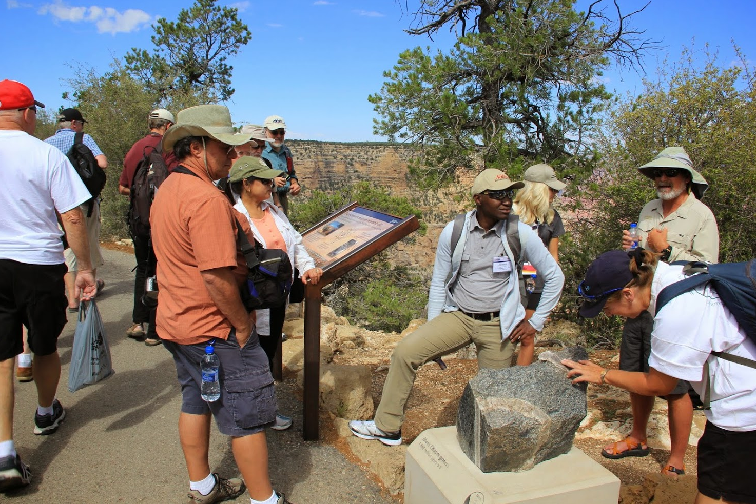 Participants viewing a sample of the oldest rock in the Grand Canyon, the Elves Chasm Gneiss.
 James A. pondering what it all means.
 Karl explaining the fossilized stromatolites from the Awatubi Member of the Kwagunt Formation.
 The Trail of Time includes numerous places with newly installed viewing tubes that help viewers see the geology better. Tubes like these are a cherished tradition at Grand Canyon National Park.
 Here I am explaining one of my favorite formations in all of Grand Canyon, the Tapeats Sandstone. It is a coarse-grained sandstone deposited in a near-shore, perhaps beach deposit.
 Brass rings are found at every meter to mark one million years of time.
 On the Kaibab Limestone at Grandeur Point.
 Viewing the Bright Angel Fault that has offset the layers about 150 feet. The trail takes advantage of the fault break through the white cliff of Coconino Sandstone.
 Our assistants on the trip, Kayla and Rylleigh from Columbus State University in Georgia.
 At the one million year marker, the meters expand to cover on hundred million years, then 10,000 years, then thousands of years, hundreds of years, decades, and finally single years. For the last 140 meters, participants can see how time is relative between geologic time frames and human time frames.
 It was a great day at the Grand Canyon! Thanks to all for participating and to the two professional organizations who sponsored us.