I am taking time out from my "Around the World" trip and writing from Luxor, Egypt where I visited King Tut's tomb today. Many friends, colleagues and one very special wife have written to me to share news of a giant
slump that has closed State Highway 89 between Flagstaff and Page, Arizona. The Arizona Department of Transportation (ADOT) is calling this a "geologic event", one that occurred on the morning of February 20 (local Arizona time). ADOT has already produced
an informative and image-rich video describing in engineering terms what happened to the road and what it might take to fix it (thanks to John P. for providing this link to me).
I can give an informal geological assessment of the rock failure as I travel that road often and am familiar with the geologic setting of that portion of the highway. It is one of the most scenic roads in all the state of Arizona.
View from Highway 89 looking west toward the upper part of the Grand Canyon, known as Marble Canyon. The slump area is located just left of this shot and earlier slump deposits are visible in the foreground. The large boulders are collapsed fragments of Navajo Sandstone that fell from the Echo Cliffs (behind the photographer) from the previous slumping events. Photo taken in November, 2007
View to the south of the Echo Cliffs (photo taken in winter, 2010). The older slump is also visible in the foreground and is a part of the recent slump area.
Great view of slump material which is common on this slope. The slump was caused by cohesion failure in the Triassic Chinle Formation. Anyone who travels Highway 89 north of Cameron will know the havoc that this shale and mudstone lithology creates in the bed of that highway. Motorists often "enjoy" a free massage since the clays and shales swell when wet, then contract as they dry.
The Chinle Formation exposed north of Cameron Arizona, displaying the soft nature of the shale, claystone and mudstone bedding. Photo taken on October 17, 2009.
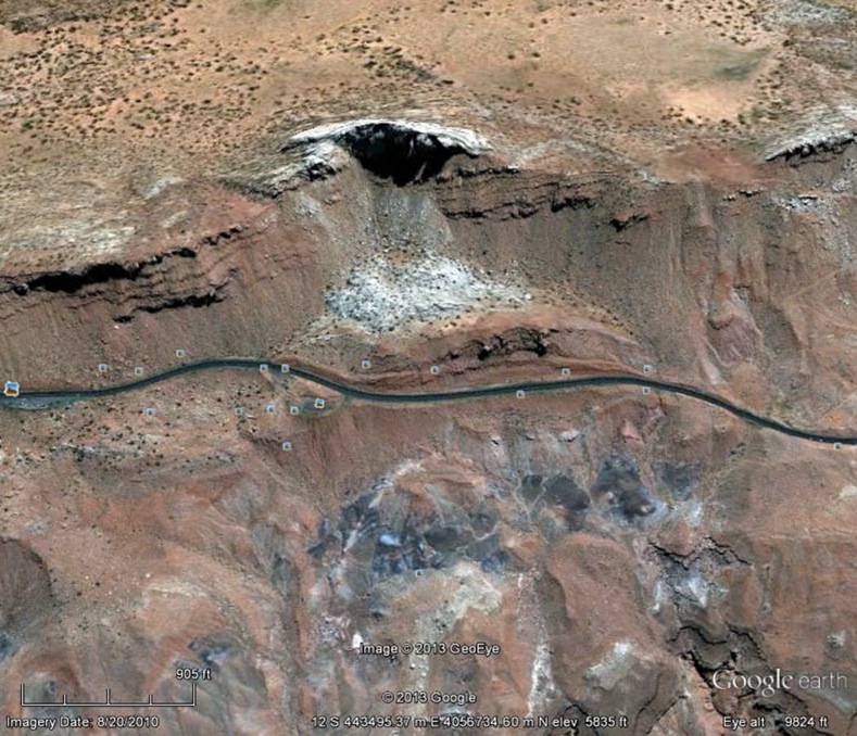
Chuck LaRue of Flagstaff sent me this Google image of Highway 89 and the ancient slump is quite obvious from this vantage. Note how the white colored Navajo Sandstone clearly has slumped downslope just above the highway in this view. Note that road construction in the late 1950's curved around the westward protrusion of the slump material.
Same image with lines highlighting the prehistoric slump area. The solid red line shows where the rocks broke away from, the dashed yellow line is the top of the slump block. This mass of rock slid downslope about 250 to 300 feet. The age of slumping is unknown to me.
A 'Halfway Around The World' Assessment - As I can believe, ADOT geo-engineers are on site evaluating options. Some rumors suggest that the highway may closed up to one year. The bed failure of the highway necessitates a tedious detour around the slump to State Highway 98, making a trip from Flagstaff to Page some 50 miles farther. Some brave travelers may try the unpaved Coppermine Road but likely just once if they do (the road is quite bumpy). I am sure that one viable option is to quickly pave the Coppermine Road. Some have also said that maybe the "slump route" may be abandoned. Not likely.The road is too scenic and too direct for that and engineers rarely say, "We give up" these days. Look for a massive stabilization project on this slope, very similar to that undertaken on the Mesa Verde approach road in southwestern Colorado. (There huge portions of the Cretaceous Mancos Shale have often slipped, yet the National Park Service has completed very expensive and a well-engineered solution there. ADOT will do the same here, hopefully that will be landscape interpretive friendly, and we will be able to one day travel this great road again. However, this slope will also one day again slide downhill as it has for at least the last several hundred thousand years.


Great coverage Wayne! It's good for everyone interested to have a good frame of reference to start with. Hopefully all parties involved will use your writings as a resource.
ReplyDeleteThank you for all you do. ~Brian
Hey Wayne,
ReplyDeleteGreat post. Much appreciated. Enjoy your travels fully and safely.
Tom Hoyt
Thanks for a very factual discussion of the slope failure (engineering term) on Highway 89. It's often described as a "sinkhole" which is not at all accurate. I was disappointed a few years ago when ADOT summarily dismissed the idea of paving Coppermine Road through to Gap and designating it either a state or county highway. Now the chickens have come home to roost. IF we are looking at a year to reopen Highway 89, paving Coppermine as an interim alternate is a very good idea.
ReplyDeleteThank you so much for taking time out from your world tour to explain this! I have been posting this on my Facebook page and was happy to share your blog post with them to explain the story behind the "split."
ReplyDeleteWayne,
ReplyDeleteThanks for taking time out from your world tour to explain this. I've been sharing the news of this with my Facebook folks, and it is great to share your post to help explain the "split."
Wayne - great post. Thank you so much for the explanation. Travel around here could be interesting for awhile :)
ReplyDeleteWayne, thanks for this info. I just visited this area on Mar 5, 2022 and drove this hyway. Pray tell what are those mounds of gray 'gravel' along 89 between Camaron and the area of this hyway failure. They area extremely photogenic and the climb up the mountain at the area of this terrain failure was gorgeous. Would love to come back and spend more time in this area. The geology of Arizona is breathtaking. you may email me at minorkey47@gmail.com
ReplyDelete